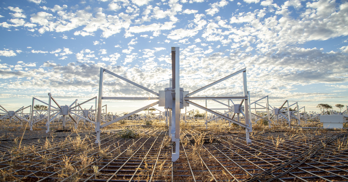
The great Western Australian outback hosts places of exquisite beauty and wildness, home to a fascinating array of animals from the iconic red kangaroos to the small, endangered bilby.
It also offers something crucial to radio astronomy—radio silence. This prevents any unwanted interference to radio telescopes, which affects their normal operation. For this reason, Australia’s Murchison region was selected to house a couple of observatories such as the Commonwealth Scientific and Industrial Research Organisation’s (CSIRO) Murchison Radio-astronomy Observatory (MRO), as well as half of the upcoming Square Kilometre Array (SKA)—the world’s most powerful radio-astronomy facility.
But unfortunately, the silence isn’t absolute. As with all Earth-based locations, radio telescopes are susceptible to radio frequency interference (RFI) from both terrestrial and astronomical sources. For example, FM-band radio signals from Geraldton, a city 300km away from The Australian Radio Quiet Zone WA (ARQZWA), have even been found to reflect off objects flying overhead, disrupting radio-astronomy experiments!
Uncovering insights.
Collaborating with Curtin University’s Professor Steven Tingay, our astronomy-HPC expert embarked on a journey to characterise sources of RFI in the ARQZWA, in an effort to improve and build on a previous study on RFI at the MRO. Peer-reviewed and published in Astronomy and Computing, this current study aims to classify objects passing over this zone, whether they’re planes, satellites, debris or otherwise, by passively detecting FM radio signal reflected off the objects.
The paper is titled: “DUG Insight: A software package for big-data analysis and visualisation, and its demonstration for passive radar space situational awareness using radio telescopes.” You can download it here.
Central to this study is the application of our flagship analytical software, DUG Insight. Its signal-processing algorithms and visualisation capabilities were highly suitable for this radio-astronomy dataset. From dynamic, easy-to-manipulate data-mining functionalities to the interactive parameterisation of workflows, DUG Insight enables rapid feature extraction testing, which was a huge benefit for this study.
Images of the sky, each containing eight seconds worth of radio signals, were continuously acquired over three days. This dataset was ingested into a DUG Insight workflow, much the same as a typical seismic dataset would be. The software’s pre-existing quality-control tests are well-suited to identifying data and acquisition-related anomalies, which are then rectified in the processing flow where necessary.
In this study, trajectories of known satellites and debris were also imported into DUG Insight, used within the processing workflow, and visualised as attributes over the dataset (see images below).
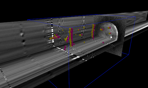
In this image, we can see the amplitudes above (pink) and below (yellow) a threshold in the images constrained in this probe. The blue rectangular prism spans approx. 100 images. Vertical and horizontal slices are rendered through all images in the dataset to highlight images which have anomalous amplitude and may need removal.
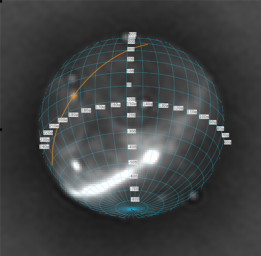
This is a single image from the dataset. The blue grid shows the right ascension and declination grid and is used to show where the horizon ends. The orange path is the trajectory of the International Space Station (ISS) over a number of frames and the cross is the predicted position in the current frame. The faint white oval shape under the cross is FM radio signal returned from a reflection off the ISS.
DUG Insight’s standard processing toolbox remained instrumental to this project. Where specialised astronomy tools and libraries were needed, the software’s Python interactive development environment (IDE) provided the ability to write domain-specific code. With this, you could interactively test and visualise code on intermediate workflow products—without the need to submit a job and commit data to disk in order to visualise results. An example of this was to quickly calculate the distance to a particular satellite in the current image that was passing over the sky. The goal is to eventually run satellite detection within DUG Insight in real-time.
We’re very excited about this development and we can’t wait to share any future updates with you, watch this space!
If you’re interested to explore what we can do to turbocharge your radio-astronomy projects, drop us a line at [email protected]!